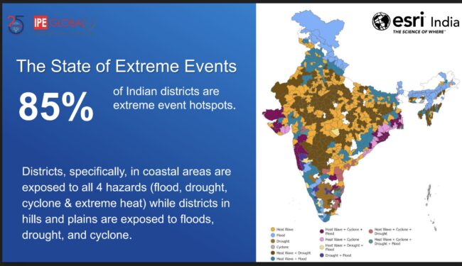
Over 85 per cent of Indian districts are prone to flood, drought, cyclone and heat waves, of which 45 per cent of them are witnessing a swapping trend, according to a independent study released today by the IPE-Global and Esri-India. The frequency, intensity, and unpredictability of these climate extremes have also risen in recent decades by four-fold. Using a pentad-decadal analysis, the study compiles a catalogue of extreme climate events over a 50-year historical period from 1973 to 2023 by employing spatial and temporal modelling, the research provides a detailed district-level assessment, exploring the complexities and non-linear trends and patterns of these events. Last decade alone has witnessed a five-fold increase in these climate extremes. The study also found that over all climate risk landscape of the Indian districts is fast changing. The study was launched at Climate Technology Summit’s plenary session titled “Leveraging GIS Technology to Mitigate Climate Risks” organised by Esri-India and its partner IPE Global – as the world is gearing up for the Climate Week NYC, USA where business leaders, political change makers are expected to deliberate the on-climate action commitments.
More than 60 percent of districts in Bihar, Andhra Pradesh, Odisha Gujarat, Rajasthan, Uttarakhand, Himachal Pradesh, Maharashtra, Uttar Pradesh, and Assam are witnessing more than one extreme climate events. The IPE Global study found that, Eastern zone districts are more prone to extreme flood events, closely followed by the north-eastern and southern zones of India. There has been a 4-fold increase in extreme flood events across Indian districts. The increase in greenhouse gases emissions, unplanned landscape planning and unsustainable anthropocentric activities are triggering these climate extremes and its likelihoods. The study finds region specific district.
Findings from the study suggest, there has been a 2-fold increase in drought events especially agricultural and metrological droughts and four-fold increase in cyclone events.
The study found a trend that more than 45 per cent of Indian districts are witnessing a swapping trend i.e., with some flood-prone areas now becoming more susceptible to droughts, and vice versa and combination of both the hazards. The number of districts that have transitioned from experiencing floods to facing droughts surpasses those that have shifted from droughts to floods. Several districts, including Srikakulum, Cuttack, Guntur, Kurnool, Mahbubnagar, Nalgonda, and Paschim Champaran, among others, have seen this reversal from floods to droughts. Southern India, particularly states like Andhra Pradesh, Tamil Nadu, and Karnataka, are witnessing a notable increase in drought conditions. Bengaluru Urban, Pune, Ahmedabad, Patna, Prayagraj districts are witnessing the maximum swapping trends. Districts such as Rajkot, Surendranagar, Ajmer, Jodhpur, and Aurangabad have also exhibited both flood and drought. Districts in the states of Tripura, Kerala, Bihar, Punjab, Jharkhand are observed with maximum swapping trends.
The study also found that districts that identified district hotspots have undergone a 65 per cent change in land-use-land-cover. These changing patterns are due to microclimatic changes across the Indian subcontinent that are triggered by local climate change drivers such as land-use-surface change, deforestation, encroachments upon mangroves, and wetlands.
The study recommends that establishment of a Climate Risk Observatory (CRO), a risk-informed decision-making toolkit for decision-makers at the national, state, district, and city levels under its National Resilience Programme and establishment of an Infrastructure Climate Fund (ICF) to support sustained investment into climate-resilient critical infrastructure and foster locally led climate actions. ICF can be geared towards enhancing the markets’ capacity to absorb increased risk at optimal return periods, fortifying their ability to navigate the ever-evolving landscape of risks adeptly.
The IPE Global and Esri study holds significance as it provides a micro-level hazard assessment of climate extremes across Indian districts. It argues that comprehensive risk assessments at the hyper-local level are the need of the hour and relying just on global models will not be effective. Moreover, identifying and estimating climatic risks is one of the global call-to-action to climate-proof lives, livelihoods, infrastructure and economies at the India pitch to United National Framework on Climate Change’s reporting.
This study represents a pioneering effort in profiling extreme climate events—such as heatwaves, cyclones, floods, and droughts—at the district level across India. By employing spatial and temporal modelling, the research provides a detailed district-level assessment, exploring the complexities and non-linear trends and patterns of these events. In addition to evaluating the frequency of climate disasters, the study investigates the patterns of related events and how their impacts have intensified over time. The study also examines shifts in climate event trends across various sub-regions of the country. Using a pentad-decadal analysis, the study compiles a catalogue of extreme climate events over a 50-year historical period from 1973 to 2023.
Agendra Kumar, Managing Director, Esri India, said, “Building climate resilience requires maintaining a delicate balance of both climate adaptation and mitigation approaches. Geography is key, be it for understanding future climate projections for policy interventions or efficiently planning intervention approaches such as nature-based solutions, technological solutions, or social solutions. GIS technology, with advanced spatial analysis tools and the ability to integrate a variety of data, enables this geographic science approach. GIS technology is already the core foundation of various environmental initiatives, disaster resilience programs, infrastructure, utilities, natural resources management, and missions like smart cities, AMRUT, National Water Mission, and Clean Ganga among others. GIS-driven solutions like Climate Risk Observatory with vulnerability maps, apps, and data have the potential to help stakeholders better understand the sectoral impacts of climate change and build a more resilient future.”


